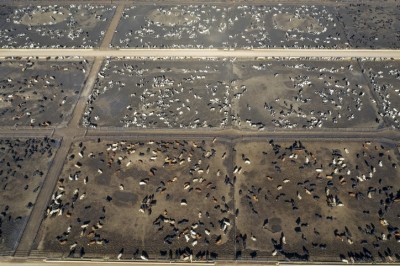
Report locates CAFOs, cites pollution concerns in North Carolina
The group, comprised of the Waterkeeper Alliance, Environmental Working Group (EWG) and North Carolina Riverkeeper organizations, released the interactive map on Tuesday in an effort to document feeding facilities for swine, cattle and poultry across the state.
“These maps show for the first time, that thousands of CAFOs and the animal waste they produce are often adjacent to communities and vital water sources,” said Ken Cook, president and co-founder of EWG.
The models can be searched for feeding operations across the state, concentration by county, operations near watersheds and by census block group. Waterways like the Catawba River are dammed in places to establish drinking water reservoirs and may be downstream from animal facilities.
One concern of the organizations was the proximity of feeding facilities and the generated animal waste to state waterways, as animal waste may alter water quality, they said. Researchers with the groups calculate that about 10bn gallons of wet waste and 2m tons of dry waste may be created from the different facilities every year.
Tool for future action
It took three years for the mapping project to come to fruition, said Dan Estrin, general counsel and legal director at Waterkeeper Alliance. “It will be an extremely useful tool for CAFO neighbors and other members of the public, advocates, academic researchers and even regulators to utilize in all manner of their work addressing the impacts of industrial agriculture in North Carolina,” he added.
The initiative will expand to include feed mill location mapping as well to identify potential areas of future growth in animal production facilities.
“Feed mills determine the future growth of the industry and where these new barns will be,” said Estrin. “New clusters of barns are centered on the feed mills.”
Additionally, processing plants are set to be included on the expanded maps as the organizations have previously found discharge problems, he said. “Each processing plant has wastewater discharge that should be monitored in conjunction with the rest of the industry,” he added.